
Tiles: Map Your Adventures
Turn Apple Health workouts into a private route map
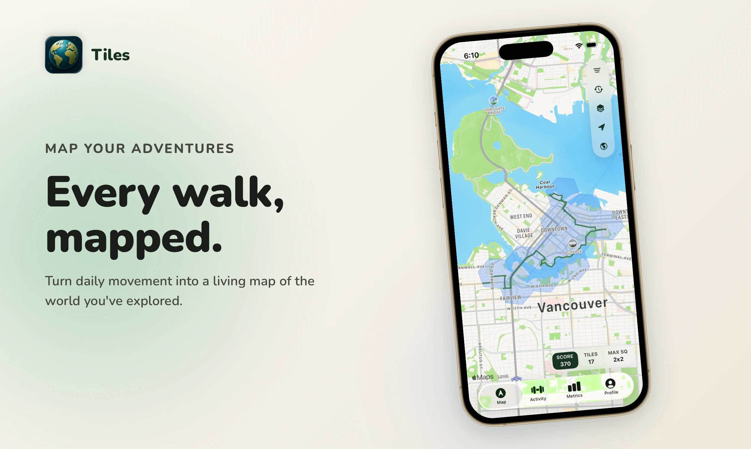
Tiles turns Apple Health workouts, GPX, FIT, CSV, and photos into one local-first private exploration map. See everywhere your walks, runs, hikes, rides, and trips have taken you, spot the gaps you have not explored yet, and share milestones without creating an account.
AI Analysis
Tiles is a local-first, privacy-centric app that aggregates Apple Health workouts, GPX, FIT, CSV files, and photos into a unified personal exploration map. Key features include visualizing all past walks, runs, hikes, rides and trips, identifying unexplored geographic gaps, and sharing milestones without requiring user accounts. It solves pain points like fragmented fitness tracking data, privacy risks in social fitness platforms, and the lack of a comprehensive private overview of personal adventures. The value proposition centers on complete data ownership, offline functionality, and seamless multi-format integration for health-conscious users seeking private mapping insights.
In 2025-2026, market timing is favorable due to heightened global data privacy awareness, continued growth in wearable devices and Apple Health ecosystem adoption, and sustained post-pandemic demand for personalized fitness tools. Users increasingly seek alternatives to data-heavy social apps amid regulatory focus on privacy (e.g., GDPR expansions). Local-first mapping technology is mature with better offline capabilities on mobile devices. This positions Tiles well as a private alternative in a growing digital health market. Rating: Excellent Timing.
Overall feasibility is High. Technical challenges involve parsing multiple file formats (GPX/FIT/CSV) and local map rendering, which are solvable with established libraries and Apple's frameworks. Development costs are moderate for a mobile app with no heavy backend infrastructure due to local-first design. Low supply chain risks, strong alignment with privacy compliance, and good scalability as user data stays on-device. Potential challenges in map data accuracy and iOS-specific optimization, but no major barriers for an experienced team. Rating: High.
Primary users are tech-savvy fitness enthusiasts and outdoor adventurers (runners, hikers, cyclists) aged 25-50 who use Apple devices (iPhone/Apple Watch). Geographically concentrated in US, Europe, Canada, and Australia with high Apple penetration. Core pain points include data fragmentation across apps and privacy fears from cloud-based social sharing. TAM is part of the $100B+ global digital health/fitness market; SAM for activity mapping apps approx. $5-10B; SOM for privacy-focused local mapping is a niche of several million users. Willingness to pay is moderate-to-high for premium features like advanced analytics or ad-free experience.
Competition level: Medium. Direct competitors: 1. Strava (strava.com) - social network for athletes. 2. Komoot (komoot.com) - route planning and navigation. 3. AllTrails (alltrails.com) - trail discovery and hiking maps. 4. Gaia GPS (gaiagps.com) - offline mapping for outdoors. Advantages: superior privacy (local-first, no account required), unique gap-spotting feature, broad format support beyond just activity tracking. Disadvantages: lacks social/community features that drive engagement in Strava/Komoot, potentially higher learning curve for map visualization, and may require paid upgrades for full functionality while competitors have established freemium models with larger user bases.
Upgrade Pro to unlock full AI analysis
Similar Products

TouchGrass
Context-aware break reminders without invasive permissions
▲ 299 votes

Midjourney Scanner
60 second ultrasound-based full-body scanner that beats MRI
▲ 206 votes

Walkable
Safety-first walking navigation to walk the safest routes
▲ 134 votes

Cercle
The bat signal for your closest friends.
▲ 121 votes

Edit Mind × Strava
Every clip matched to the Strava activity it's from
▲ 92 votes

Grayscale for Safari
Turn Safari black & white and browse with less distraction
▲ 77 votes